History Along the Way
Part of the J. Shelton Gordon collection of historic letters on the history of the Antelope Valley (see also the Anna and Norman Ross page). Describes scenes along the Angeles Crest Highway with a brief mention of Loomis Ranch.
________________________________________________________________________
HISTORY ALONG THE WAY
By Eleanor T. Opid
July 10th 1971
When you travel the Angeles Forest-Angeles Crest Highway thru the San Gabriel Mountains - on your way to the densely populated "mountains to the sea" on the other side DO you sometimes wonder about the history along the way.
From the Mill Creek Saddle, not too far from the present picnic area, the old trail left to climb up and over Mt. Pacifico there to descend to the beautiful Loomis Ranch located at the head of Alder Creek which farther down emptied into the Big TuJunga Stream. Back in 1911 Captain and Mrs. Lester Loomis homesteaded there. Their's was a place that radiated warmth and friendliness to all who were privileged to be guests or merely pass thru.
The Colby sign directs to a wonderful Church Camp operated by the Southwest Conference of the Methodist Church. "Colby Ranch" was homesteaded by Delos and Lillie Colby back in 1891. A beautiful spot near the base of Strawberry Peak where forest and springs of cold water gave abundant supply. Apples and cherries grew for home use and to pack out for sale - no roads, only trails. Colby's was a favorite stop-over spot for fishermen and hunters (open territory then) who frequented the Big TuJunga. Building materials and store foods were animal packed in - first from Acton and later from Pasadena via the Arroyo Seco.
There were prospectors who found it interesting all along Mill Creek and the Big TuJunga and tributaries. Some of them were George Cogswell, Tom Clark, Ed Fuller, Tom Lucas, and Fred and Gertrude Carlisle. Then there was Bill Houck who had a cabin in Mill Creek not far from the present eating place on the right side of the road. Bill was a jolly, jovial man who dearly loved his mountains.
On across the high bridge that spans the Big TuJunga and up the grade one soon crosses into Clear Creek Canyon. Here the Los Angeles School System has had for years a Forestry School Camp for their boys and girls. They have planted most of the pine trees close to the road all the way to the saddle where the present Forestry Station is. Here the road meets the Angeles Crest Highway - - one goes either to the right to the Los Angeles area OR to the left, on up toward the Red Box Divide and where the West Fork of the San Gabrial and the Arroyo Seco Canyons meet. Just a short distance and down to the right is the Waterman Forestry Station. A little way below there was Switzer's Camp. Switzer's Camp was the dream and creation of Commodore Perry Switzer in 1883. This was the first resort camp in the mountains above Pasadena. The Bob Watermans who had spent their honeymoon hiking and camping in the general region became friends of Commodore Switzer. In fact, Mt. Waterman is named for Mrs. Waterman, the first white woman to have climbed the mountain. Waterman Station is named for Bob Waterman. years afterthe fire which destroyed so much of the Arroyo Seco and Switzer's Camp, and the natural beauty had returned,the Lloyd B. Austin family created what became -- first "Camp Losa-Dena"to represent Los Angeles and Pasadena - that was in 1912.) Soon it was recognized that Switzer's Camp (later Switzer-Land) became the beloved spot for thousands of hikers. Standing just above a waterfall at the lower part of the camp was the artistic stone chapel -- the only one of its kind within these mountains. Ultimately this was torn down by the U.S. Forest Service -- apparently for safety sake -- the last reminder of the camp that had given pleasure to so many.
Back to the Angeles Crest Highway -- to the left a trail followed up thru a long canyon, over the shoulder of Strawberry Peak and down to Colby Ranch.
Continuing the climb, one reaches the Red Box Divide where a U.S. Forestry Station is and where the road forks three ways -- left to follow the main road - to the right on to Mt. Wilson, - the center leads within a mile to the site of Opid's Camp, created in 1914 by John T. and Eleanor T. Opid - a beauty spot in heavily timbered, stream fed canyon coming down from San Gabrial Peak and Disappointment Flats. This is now owned and operated by the City of Long Beach by their Recreational and Educational Departments for their sixth grade children. For over 27 years, Opid's Camp realized the pleasure of welcoming thousands of guests.
Two miles below in the main West Fork "Valley Forge Lodge" was built and operated by Ernest and Cherie DeVore. Another beautiful spot enjoyed by so many.
TRY today -1971- to picture this mountain route with only trails, riding and pack stock to transport everything -- except, what was human back-packed and that was plenty. At the higher altitudes, supplies had to be packed in for three to four months on account of the winter snows closing the trails for stock. -----YES, right here in the San Gabriel Mountains!
It seems you have been taken away from the down road to Los Angeles Basin -- yes, there is some history that way too, but maybe not so interesting. The Angeles Crest Highway takes you thru so much beauty - you hardly realize that you are within the mountains so very near. Pack a lunch and try the whole way thru to Big Pines Park and home into Antelope Valley.
Eleanor T. Opid
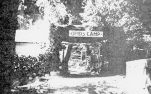
1914 - 1941 Picture taken in 1937